Nukes, Native Houses, and National Sites in Los Alamos, NM

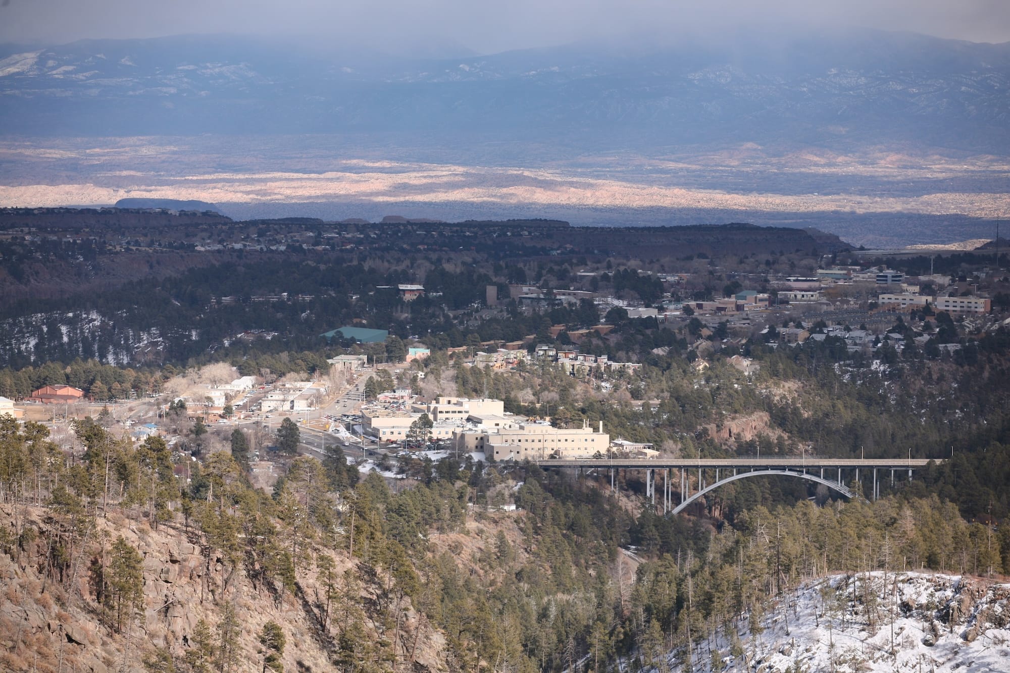
Los Alamos sits on four mesas amidst the Jemez Mountains of northern New Mexico. The town has been made famous by its three Ns: nukes, native dwellings, and national sites.
In the popular mind, Los Alamos is likely best known for being the birthplace of the atomic bomb. This most devastating of weapons was developed in the closing years of World War II at the Los Alamos National Laboratory, which headquartered the Manhattan Project.
Due to the secretive nature of the Manhattan Project, Los Alamos was known officially as Site Y. A closed community at the time, entrance to the site was guarded by two gates, one of which remains along SR 502.
If you’re interested in the history of atomic weapons, Los Alamos is the place to be. The Manhattan Project National Historical Park houses preserved buildings from the days of the first atomic bomb’s development. They include the Oppenheimer House, which was the home of infamous physicist J. Robert Oppenheimer, often called the Father of the Atomic Bomb.
The Pueblo Ruins
The second N in Los Alamos are the Native American cliff dwellings that cover the surrounding mountains. Long before American war industry split the atom, Ancestral Puebloan peoples lived around the Los Alamos, Barrance, North, and South mesas.
It’s not hard to find the ancient cave homes—pick a direction, hike for a bit, and you’re bound to hit some. However, some of the most famous dwellings are located in Bandelier National Monument. The monument’s nearly 34,000 acres feature numerous hiking trails that take you to ruined settlements both on the ground and up on the cliffsides.
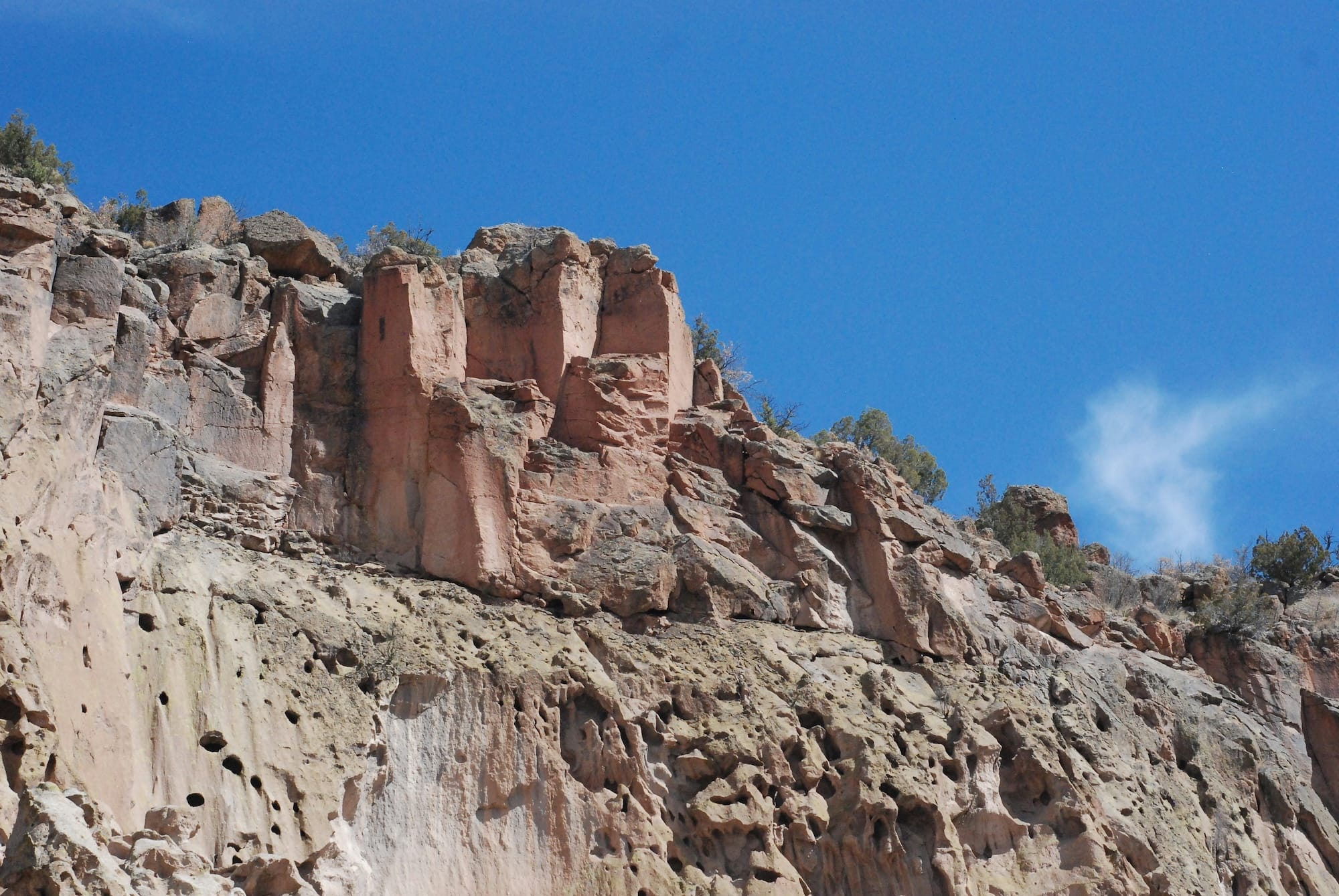
Perhaps the most famous location in the area is the Alcove House (named Ceremonial Cave on some older maps). This cave was used by Ancestral Puebloans and features a reconstructed kiva, an underground ceremonial chamber.
You can hike and climb to the cave (it requires scaling rickety ladders), but the kiva is closed to the public at the time of writing due to structural concerns and—unfortunately—persistent vandalism.
Another site worth visiting is Tsankawi, a detached unit of Bandelier National Monument to the east of Los Alamos. Here, you can get a very close look at the ancient cavates (that is, cliff dwellings) and see some well-preserved petroglyphs. For more of the latter, visit the Painted Cave in the main monument area.
Ranching History
The final N stands for National Sites, which I’ve already listed two of. But there’s also Valles Caldera National Preserve, a 14-mile-wide ancient volcanic caldera. This old ranching land is covered by expansive meadows, gentle streams, and abundant wildlife.
For more information on Los Alamos’ pre-Manhattan Project ranching history, take a peek at the Los Alamos History Museum, whose exhibits tell the area’s whole history. Meanwhile, the Los Alamos Nature Center teaches you about local flora and fauna.
Not enough rugged desert beauty for you? Venture south to the Kasha-Katuwe Tent Rocks National Monument, where you can marvel at incredible conical hoodoos and claustrophobically narrow, meandering slot canyons. Afterward, stop by to camp or swim at the nearby Cochiti Campground and Cochiti Lake Recreation Area. All of this is located on Pueblo de Cochiti land, so don’t be like the vandals at Alcove House and treat the awesome (in the classical sense) nature with respect.
Los Alamos is also located within the Santa Fe National Forest. So, if you’re still craving more hiking trails and scenic overlooks, they’re all over the place.
Granted, you may want some urban comforts after all this. Luckily, Santa Fe and Albuquerque are both within a quick ride.
Facts & Info
Nearby Attractions
- Manhattan Project National Historical Park
- Bradbury Science Museum
- Bandelier National Monument
- Alcove House
- Tsankawi
- Valles Caldera National Preserve
- Los Alamos History Museum
- Kasha-Katuwe Tent Rocks National Monument
Nearby Roads
SR 4 is a squiggly road that branches off SR 502 just before you begin the climb to Los Alamos. It’s a scenic, curvy ride that boasts stunning vistas of the desert, mountains, and mesas. It also takes you to many of the area’s sights, like Tsankawi, Bandelier, and Valles Caldera, alongside many hiking trails. Note that the pavement can be worn out in some places.
SR 126 connects SR 4 to the town of Cuba in the west. It offers more mountain curves through woods, meadows, and streams.
Riders looking to do a longer ride should head east to Española and hit the High Road to Taos. This 75-mile ride takes you up to the Sangre de Cristo Mountains, where you’ll pass several pueblos. They welcome visitors, but remember to act according to their rules (which often prohibit photography).
If you’ve completed the Taos road, you might as well take the curvy US 64 east to Angel Fire and return south along SR 434. Terminating at Mora, it proceeds through Taos Canyon and brings even more rivers, mountains, and twists to the table.
Food & Dining
The hallmark of New Mexico cuisine is the state’s famous green chiles. You can enjoy at virtually any eatery in Los Alamos, but some highlights include:
- Blue Window Bistro prepares delicious American classics and New American dishes and sets plates on tables surrounded by quirky Land of Enchantment decor. Find it at 1789 Central Ave.
- Muy Salsas is your destination for mouthwatering authentic Mexican dishes featuring the signature green pepper. Find it at 1315 Trinity Dr.
- Pajarito Brewpub and Grill is the local go-to stop for BYOB (build your own burger) and a long list of beers for an after-ride refreshment. Find it at 614 Trinity Dr.
Best Time to Travel
For motorcyclists, Los Alamos is at its best from early summer to early fall (June through September). The temperatures up in the mountains are cooler than in the desert below, keeping the region comfortable for two-wheeled exploration in the summer. You also get nearly 15 hours of daylight in June, the snow has melted off the mountains, and off-road riding is at its best with little rain in the forecast.